So anyway, after staying in Auckland for a few weeks, I was anxious to get out of the city and get a break from schoolwork. The weekend of Sept 30th I set out to explore the tip of the North Island with Ammar, Ross, and Allie. Unfortunately, we didn't have the best weather, but we made the most of it and had an absolute blast anyway, doing a range of activities from hiking, to kayaking, caving, and duneboarding, which I'll talk more about later.
Our map/itinerary--we covered a lot of ground
Friday
We left Auckland in the morning after picking up the rental car and headed straight north on Highway 1 for the city of Whangarei. The city itself, the biggest in the Northlands (the region north of Auckland), wasn't the main attraction, but rather a host of activities we could do in the area.
First, we checked out the Abbey Caves. Having already been to the spectacular caves in Waitomo, I was a little skeptical, but I ended up being completely blown away. It might have been the fact that our expedition was free and non-guided, or maybe because it was overcast and there was the threat of rain (which you definitely don't want there to be while you're inside a cave), but regardless, it felt a lot more daring and adventurous.
On the walk to the caves we went through fields of stratified limestone boulders that had been weathered by rainfall, resulting in some fantastic "fluted" rocks (upper right in second photo).


After passing a few openings, we decided to enter Ivy Cave first, which had a gaping entrance.

We turned on our flashlights and followed the river flowing into the cavern as the darkness slowly enveloped us. It was a little unnerving to plunge into the unknown depths of the cave, but the awesome cave features drove us to continue on. Stalactites hung from the ceiling, calcite slime and drippings covered the walls, and glow worms twinkled in the dark when we paused and turned off our lights. The cave had low ceilings in some parts and required a few tight squeezes, but at times it would open up the ceiling hung over 30 feet above us.


 Posing for a group photo in the dark
The next cave we checked out, Organ Cave, was very different. It was basically a single, tall, narrow passage with an ice cold stream running along the bottom.
 It didn't seem like anything special, but at the far end it opened up into a wide chamber, which was FILLED with luminescent glow worms. Sadly this is one thing I couldn't capture with my camera, but I managed to get a shot of a glow worm and its silk web in the light of my camera flash. The glow worm is the thicker part of the horizontal string on the right.
Next, we checked out the 26m Whangarei Falls. My guidebook likened it to Paris Hilton, stating that it's "not the most impressive, but reputedly the most photographed" waterfall. It was indeed picturesque, but what made it really special was that we were able to walk around the pool of water at the base and actually go behind the falls.


Saturday
The next morning we drove further north to the town of Paihia in the Bay of Islands, a tourist hot spot. The problem with the area, though, is that to truly experience it, you need to pay for activities like sealife-spotting cruises, or ferries out to the islands. Being budget college travelers, however, we opted to go sea kayaking instead. The weather was still pretty crummy, no sunshine and overcast skies, but we went for it anyway. The guy at the rental was shocked that we were going. We got nervous when he started cracking jokes like, "Do you guys have insurance?" It ended up being a total blast though, and the poor weather made for some big waves, which only made it more fun. Getting into and out of the water was a little tricky with the surf, though. On the way out Allie fell in the water trying to jump into her kayak, and on the way back in Ammar got completely wiped out by a crashing wave. I almost capsized myself I was laughing so hard. It was a really fun adventure, but it wasn't too surprising to learn from the rental shop guy afterwards that we were the only customers of the day.

Next, we continued our journey north to the town of Whangaroa, where we had read about a short walk up St. Paul's Rock. The track was extremely muddy and slippery due to the rain, which made climbing tricky. After walking up the grassy hill, we reached the rock outcrop at the top, where chains were bolted in to help with the climb.


Upon reaching the summit, we were rewarded with spectacular views of the harbor. We took a bunch of group pics, and I ended up slipping and wiping out in an attempt to make it before the 10 second self-timer went off, which the camera captured perfectly.


By now it was around 4pm, and we had a race against the clock to make it to the town of Kaitaia, where we hoped to rent a sandboard from the iSite there which closed at 5pm. It ended up being a photo-finish, with us pulling into the parking lot literally just as the woman was closing the door. We all shouted out for her to stop and wait. Lucky for us, she turned out to be very nice, and opened up the shop to loan us a board for the next day.
Feeling relieved, we completed the last leg of the journey north to Cape Reinga, the tip of the North Island. We had a brief glimpse of the giant Te Paki Sand dunes, which we planned to explore the following day, when suddenly a dense fog set in. We couldn't see 30 feet in front of the car!

It was a bit depressing because we kept passing all of these lookouts, signs, and rest stops that we assumed usually provided sweeping views, but we couldn't see a thing.
Cape Reinga is a sacred place for the Maori, who believe that it is the place where the souls and spirits of the deceased depart from this world. At the very tip of Cape Reinga is a lighthouse, which has become a major tourist attraction. We had been looking forward to watching the sunset from the lighthouse, but obviously with the current conditions that wasn't going to happen. We decided to camp at a nearby DOC campground and hope for better weather in the morning.
Sunday
We woke up at 6am to try and watch the sunrise at Cape Reinga, but sadly the dense fog still lingered over the cape. But having come this far, of course we had to still check out the lighthouse, so we set out towards it... except we weren't even sure we were going the right way! There wasn't a single sign, and yet there was a fork in the path right at the start. We assumed there were no markers because normally in fair weather, you can see that the lighthouse is just up ahead.
As we walked blindly through the fog, suddenly a beam of light pierced through the haze. We had found the light house! We were just able to make out the ocean and cliffs below. We snapped a few pictures, but didn't stick around for too long, and hurried back to the car. It was a shame we couldn't see more of the surrounding scenery, but the fog was also pretty cool because it contributed to the spookiness of the place and the legends behind it.


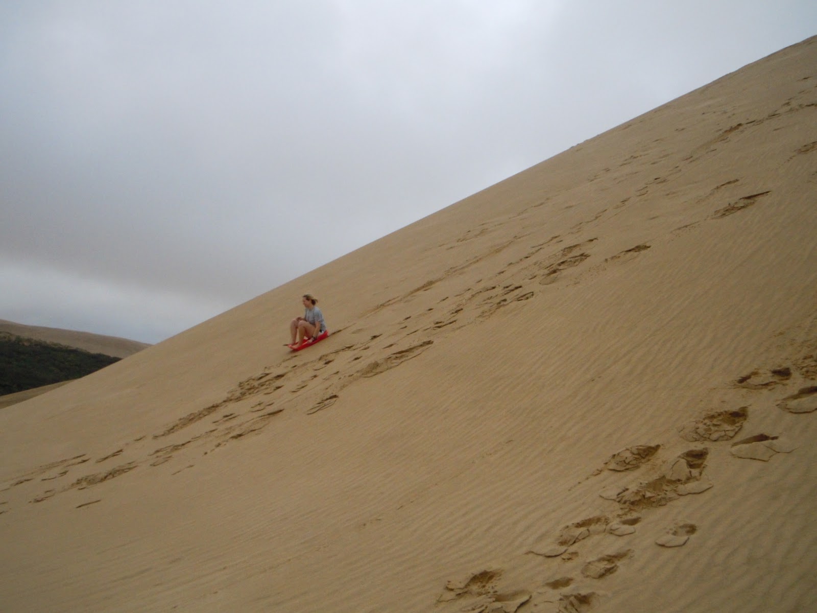
Next, we drove south back to the Te Paki Sand dunes, where we were excited to try the renowned duneboarding. After a short drive we finally came out of the fog, which seemed to be localized to JUST Cape Reinga. What a joke. It still was gray and gloomy out, but at least now we could see. As we drove, the sand dunes came up completely out of no where. One moment we were driving through trees and grassland, the next the dunes lay ahead of us, as if we had suddenly entered a desert.

Feeling a bit nervous about how duneboarding would work exactly, and not knowing what kind of speeds we would attain, we walked up halfway a small dune and to try it out. Allie went first, and did it like a pro. Ross and Ammar went next, both having epic log roll wipe outs. I went last and didn't crash, but was ready to go bigger and faster.

Before sledding some more, we walked around and explored the dunes, which covered a vast area. Even though the dunes were wet from all the rain, the wind was still able to kick up some sand, and we were blasted as we walked around.

Finally, we came to a giant, crazy steep dune, which everyone else refused to try. I really wanted to give it a go, though, so I went for it. It was AMAZING! Terrifying, but so exhilarating.
On a slightly smaller dune, I convinced everyone to go. Ross and Ammar made it okay, but Allie had a major wipeout. I kind of don't know how she didn't sustain any brain damage, because she did a hardcore faceplant.

But she's okay! Good sport.
Being a huge fan of roller coasters, I was totally obsessed with duneboarding. After I took a good 5-7 runs, we finally left the dunes with smiles on our faces.
For our last stop we drove to the Waipoua Kauri Forest, a sanctuary for the giant kauri trees that once dominated the Northland's landscape, but are now limited to small patches of forest like this one due to aggressive logging. We planned on walking around to see many of the large kauri, but it started POURING on the drive there. So instead we sprinted to snap a couple pictures of the mighty Tane Mahuta, "Lord of the Forest," before driving back to Auckland.
For our last stop we drove to the Waipoua Kauri Forest, a sanctuary for the giant kauri trees that once dominated the Northland's landscape, but are now limited to small patches of forest like this one due to aggressive logging. We planned on walking around to see many of the large kauri, but it started POURING on the drive there. So instead we sprinted to snap a couple pictures of the mighty Tane Mahuta, "Lord of the Forest," before driving back to Auckland.

Tane Mahuta is the largest kauri tree alive standing at 51.2m high, 13.8m around, with a wood mass of 516.7 cubic meters, and is an estimated 1250-2500 years old.